Tier 1 Environmental Impact Study in progress from I-64 near Evansville to I-465 in Indianapolis (FR Notice), and a preferred corridor has been selected. Portions of existing SR 37 between Bloomington and Indianapolis will become part of I-69.
No study has been done on the route for I-69 around Indianapolis, although use of the I-465 beltway is almost certain.
It is safe to say that the I-69 route from Evansville to Indianapolis is the most controversial segment of the proposed highway. The controversy is so great that it is difficult to obtain reliable information about the costs and benefits of the proposed routes; for example, it is alleged by advocates of improving existing highways like U.S. 41 that following the existing I-70 and U.S. 41 corridors would add just 12 miles to the route, while advocates of a “cross-country” (or “new terrain”) route including Bloomington suggest that the savings would be between 25 and 35 miles (my work with a map and a ruler suggests the latter assertion is closer to the truth, assuming a start point of the I-64/I-164 interchange and an end point of the I-70/I-465 interchange in Indianapolis). It also seems that, on average, people in Terre Haute want I-69 to pass near Terre Haute, while people in Evansville want it to go through or near Bloomington, though this is just a preliminary impression. My theory: improved access to Bloomington is probably a higher priority for Evansville residents since they already can get to Terre Haute quite easily on existing roads.
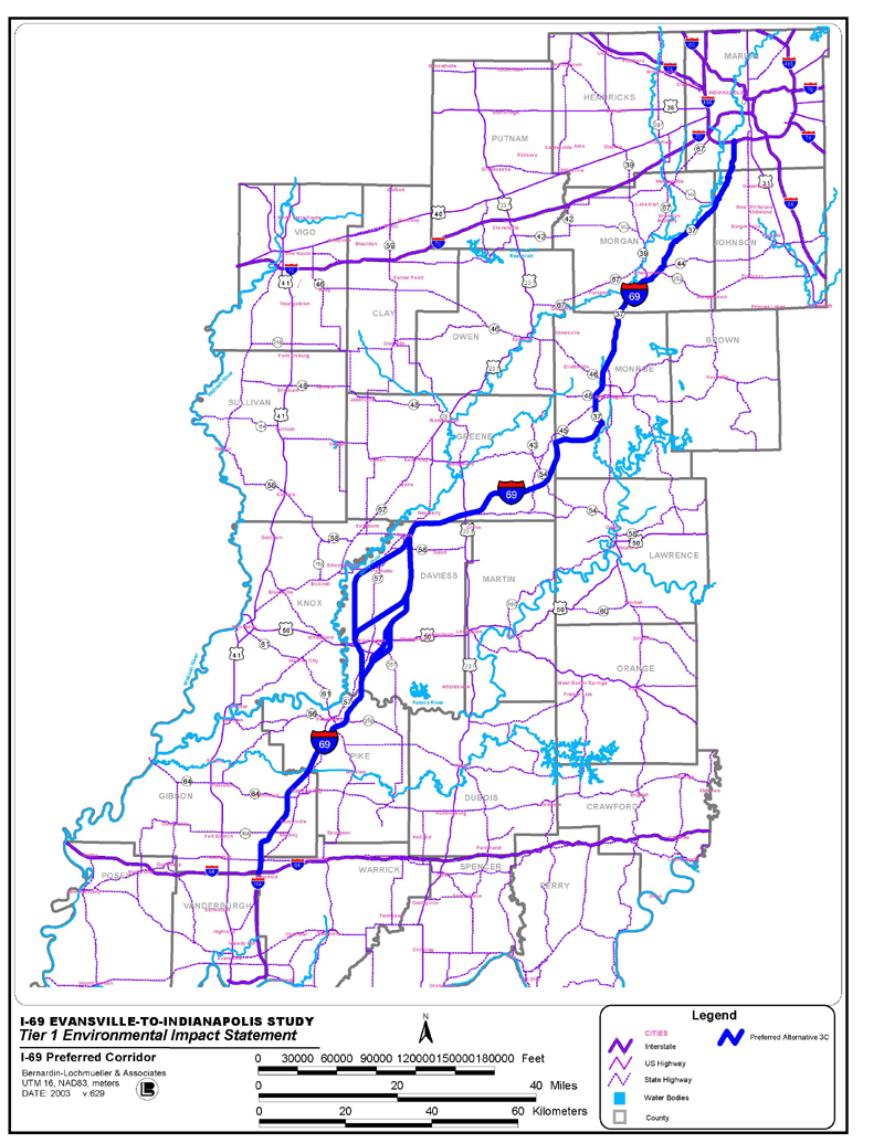
At the moment, the routing is being examined by an outside consultant for Indiana's DOT; their website is at www.i69indyevn.org. In January 2003, a preferred alternative corridor was selected for the route, Alternative 3C, which is illustrated on this map [JPEG; 639k]:
From the I-64/I-164 interchange north of Evansville to Washington via S.R. 57, bypassing Washington to the south and east, then proceeding to the general Bloomington area over new terrain, and on to Martinsville and Indianapolis via S.R. 37, ending at I-465 just west of the existing I-465/S.R. 37 interchange (based on preliminary Route Concept F).
The estimated cost for the route is $1.7 billion (around 20% of the national estimate of $8.8 billion), of which the federal government will pay 80% and Indiana will pay 20%. The state estimates that it will reduce travel times between Indianapolis and Evansville by 26 minutes and reduce serious injury accidents by around 1,500 per year. The construction work will take between 8 and 14 years.
INDOT plans to divide the route into six major sections for Tier 2 planning, which will select the final right-of-way and interchange locations for the route, according to this press release:
Regardless of which route is selected, farmland will be taken for the new highway, and there will be environmental impacts. Even if U.S. 41 is followed for much of the route, existing businesses and residences will have to be displaced or bypassed, and farming land in the Wabash Valley will be paved over.
Using existing U.S. 41 and I-70 (along with the proposed southeast Terre Haute bypass, IN 641) has some advantages: it would probably reduce the environmental impacts somewhat, and speed traffic along the U.S. 41 corridor. One downside is that I-70 will probably have to be upgraded to six lanes sooner than otherwise necessary (though probably not immediately), perhaps all the way to Terre Haute; while the land needed is mostly acquired already, improvements would disrupt the traffic along the heavily-travelled route. Along U.S. 41, more exits would be needed for access to existing property than along a new terrain route, which might promote interchange sprawl. From an economic development standpoint, Terre Haute probably needs a complete eastern beltway (improving the IN 63-U.S. 41 route to Chicago) more than it needs I-69.
A new terrain route has advantages of its own. It would greatly improve access to Bloomington from Evansville, a trip characterized today by numerous small towns and dangerous two-lane highways. Evansville is also the only major city in Indiana not connected to Indianapolis by a direct highway link; not many people would look at a map and say that a direct route to Evansville would go through Terre Haute. On the other hand, such a route would probably promote “undesirable development” in places that haven't seen it in the past, and might disrupt more farmland than following U.S. 41.
In Indianapolis proper, there is less real controversy. I-69 will probably be routed along the I-465 beltway (if I-69 follows SR 37, probably to the east; otherwise, probably to the west), although some have advocated a routing through the city instead, at least from the I-65/70 split through northwest Indianapolis to the existing I-69 terminus roughly along the old SR 37 (Binford Blvd) corridor. (See Kurumi's I-x65 page for details on the proposed route, which would have been called “I-165” had it been built in the 1980s.)
Evansville Area | I-69 Home | Indianapolis-Port Huron